Salinity Pilot-Mission Exploitation Platform (Pi-MEP):
A hub for validation and exploitation of Satellite Sea Surface Salinity data
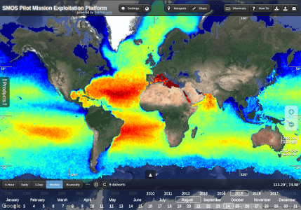
The Soil Moisture and Ocean Salinity (SMOS) mission was launched in November 2009 as the second Earth Explorer Opportunity mission. It has been continuously providing brightness temperature data in L-Band since January 2010, which are used to retrieve Soil Moisture (SM) and Sea Surface Salinity (SSS) data over land and ocean, respectively. This project funded by ESA aims at implementing a Pilot Mission Exploitation Platform (Pi-MEP), with a primary focus on ESA's SMOS mission, to support enhanced validation and scientific process studies over the ocean. Since 2019, through sustained partnership with NASA, the Platform has extended its focus also to SMAP and Aquarius satellites, becoming an overall satellite salinity Platform.
Pi-MEP project objectives:
- Focus 1 - Enhanced validation of satellite SSS and products assessment
- Focus 2 - Oceanographic exploitation and case-studies monitoring

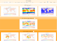
The platform provides several tools and facilities which are described in the overview.
Quick links to some of the key platform tools is given below
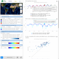
time series, scatter plots, and map charts
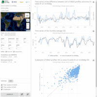
and extracting the associated data
in-situ and model, performing collocation
and generating images on the fly