Mesoscale SSS signatures in Western boundary current
Literature Review
Overview
The Gulf Stream (GS) is a strong western boundary current that originates in the Gulf of Mexico and flows northward along the North America East Coast steered by the shelf break. The current detaches from the shelf break at Cape Hatteras in a northeasterly direction separating the cold and fresher water of the continental slope from the warmer and saltier water of the Sargasso Sea (Stommel, 1965). The GS flow is strongly sheared both horizontally and vertically, it is barotropically and baroclinically unstable (Holland and Haidvogel, 1980) and typically forms meanders between the strongly contrasting water types that lie on both sides of the flow (Fuglister and Worthington, 1951). Meanders grow downstream and, when attaining sufficient curvature, undergo occlusion to form large eddies, called rings (Robinson, 1983; Kamenkovich et al., 1986). Typically, five to eight rings detach from each side of the Gulf Stream every year; warm‐core anticyclonic rings (Ramp et al., 1983; Joyce et al., 1992; Chaudhuri et al., 2009; Gawarkiewicz et al., 2012) are found north of the jet with radii between 50 and 100 km. They trap Sargasso Sea water, with noticeable isothermal and isohaline displacements to 600 m (Olson et al., 1985) although observable down to 1500 m (Carton, 2001). They usually cover 40% of the sea surface over the continental slope. Cyclonic cold‐core rings occur south of the Gulf Stream. They are both larger and deeper: their radii range from 75 to 150 km, and their dynamical signature extends down to 4000 m. They typically occupy only 10–15% of the Sargasso Sea surface and contain water from the continental slope that is less saline, colder, and more oxygenated than the surrounding waters (The Ring Group, 1981).
A large volume of water is transported across the Gulf Stream interface through GS ring‐eddy processes. As a ring decays, there is partial exchange of the waters carried by the ring with the surroundings; thus, cold‐ (warm‐) core rings generate a flux of properties from the slope water (Sargasso Sea) to the Sargasso Sea (slope water). Furthermore, because the rings trap water, a significant transfer of water properties takes place, not just at the GS frontal boundary, but well within the Sargasso Sea or slope waters. The corresponding transports of heat, salt, and nutrients have significant implications for the thermohaline circulation in the western North Atlantic and for the respective ecosystems on both sides of the GS but are still poorly known.
With the advent of spatially and temporally dense sea surface salinity (SSS) measurements from space through the Soil Moisture Ocean Salinity (SMOS), Aquarius and SMAP satellites, it is now possible to characterize the SSS variability at mesoscale in more detail in that region.
Calibration and validation efforts of the satellite SSS missions involve comparisons of satellite and in situ measurements. Such estimates of SSS can differ by the presence of small-scale variability, which can affect the in situ point measurement, but be averaged out in the satellite retrievals because of their large footprint : the Gulf-Stream frontal region characterized with high spatio-temporal variability at small scales is therefore a challenging zone for satellite SSS validation.
The advent of satellite measurements of sea surface salinity (SSS) provides a unique opportunity to study the spatio-temporal behavior of SSS in association with mesoscale oceanic features in Western boundary current from synoptic to interannual time scales. A brief summary of the major published science involving satellite SSS and the monitoring of mesoscale signatures in western boundary currents in provided in the sections here below.
Validation of Satellite SSS in an highly dynamical zone: Subfootprint variability
Calibration and validation efforts of the SMOS, Aquarius and SMAP satellite missions involve comparisons of satellite and in situ measurements of sea surface salinity (SSS). Such estimates of SSS can differ by the presence of small-scale variability, which can affect the in situ point measurement, but be averaged out in the satellite retrievals because of their large footprint. A satellite measurement of SSS represents a near-instantaneous spatial average of the surface salinity field weighted by a function related to the satellite antenna pattern over a characteristic scale that is given by the satellite footprint. If SSS is uniform over the spatial scales averaged by a satellite, then a single in situ salinity measurement anywhere within the satellite footprint provides an accurate ground truth measurement that is representative of the remotely sensed value However, the salinity field is in some places spatially or temporally inhomogeneous, so that the relationship between the instantaneous, spatially averaged salinity measured by satellite and a single in situ measurement within the satellite footprint is not well understood. In ocean regions characterized by horizontal variability with spatial scales less than the satellite footprint such as in the Gulf Stream frontal region, the subfootprint variability could be a source of difference between satellite and in situ data. When comparing salinity data taken at a point to the spatially averaged value reported by satellite, the SSS variability within the satellite footprint (i.e., sub-footprint variability) may need to be taken into consideration.
Work by Lagerloef and Delcroix (2001), Delcroix et al. (2005), and Lagerloef et al. (2010) first discussed such potential sampling errors in the satellite SSS mission associated with small-scale SSS signals. By calculating the standard deviations of 2° samples in ship transects in the tropical Pacific Ocean, Lagerloef and Delcroix (2001, p. 147) concluded that the sampling error is generally less than 0.1 psu, though it can approach 0.3 psu in the presence of "unusually strong SSS gradients." Lagerloef et al. (2010) later examined the effect of spatial averaging of the SSS data from thermosalinograph sensors (TSG) by applying a 150-km-wide Gaussian filter along the ship tracks. They found that the root-mean-square difference between the high-resolution and spatially averaged along-track values is <0.1 psu, except in the Gulf Stream region, where it can be in the range 0.3–1 psu.
To extend previous analyses, Vinogradova and Ponte (2013) examined the effect of averaging resulting from the satellite footprint using the output of a high-resolution ocean model. This study quantified how much of a difference is expected between in situ and satellite SSS measurements on the basis of their different sampling of spatial variability. Maps of sampling error resulting from small-scale noise, defined here as the root-mean-square difference between "local" and footprint-averaged SSS estimates, were derived using a solution from a global high-resolution ocean data assimilation system. The errors are mostly <0.1 psu (global median is 0.05 psu), but they can be >0.2 psu in several regions, particularly near strong currents and outflows of major rivers. To examine small-scale noise in the context of other errors, its values are compared with the overall expected differences between monthly Aquarius SSS and Argo-based estimates. Results indicate that in several ocean regions, small-scale variability can be an important source of sampling error for the in situ measurements.
Boutin et al. (2016) synthesized present knowledge of the magnitude and the processes that contribute to the formation and evolution of vertical and horizontal variability in near-surface salinity. Mesoscale to submesoscale processes can lead to horizontal variability that can also affect comparisons of satellite data to in situ data. Detailed analysis of a upper bound on the horizontal SSS variability showed regional differences : SSS spatial variability exceeds 0.5 pss in regions affected by western boundary currents such as the Gulf stream, major river plumes (e.g., the Amazon), and several coastal regions, demonstrating that, in many regions, subfootprint-scale SSS variability is larger than 0.1 pss.
Rings/meander detection in satellite SSS and correlation between SSS & SST & SLA
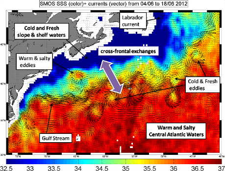
Measurements from the Soil Moisture Ocean Salinity (SMOS) satellite acquired during 2012 in the western North Atlantic were used in Reul et al. (2014) to reveal the evolution of the sea surface salinity (SSS) structure of the meandering Gulf Stream with an unprecedented space and time resolution. Combined with in situ surface and profile measurements, satellite‐derived surface currents, sea surface height (SSH), surface temperature (SST), and chlorophyll (Chl) data, SMOS SSS observations were shown to coherently delineate meanders pinching off from the current to form well‐identified salty‐ (warm‐) and fresh‐ (cold‐) core Gulf Stream rings. A covariance analysis at two locations along the separated Gulf stream path (south of Nova Scotia and in the Gulf Stream Extension) reveals a systematically higher correlation between SSS and sea level variability than between SST and SSH during the warmer half of the year. Within (75°W–40°W; 30°N–50°N), Chl concentration is also found to significantly depend on the SSS as SST increases above 20°C.
New sea surface salinity (SSS) observations derived from satellite remote sensing platforms provide a comprehensive view of salt exchanges across boundary currents such as the Gulf Stream. The high resolution (45km spatial resolution and three-day repeat subcycle) of the Soil Moisture and Ocean Salinity (SMOS) observations allows detection (and tracking) of meander and ring structures of the Gulf Stream from SSS maps. These structures are however not resolved by the relatively lower resolution (100km and seven-day repeat subcycle) of Aquarius observations. A recently developed fusion technique, based on singularity analysis technique, was applied by Umbert et al. (2015) to reconstruct these mesoscale (from 100km and 3 days) features in Aquarius-derived products. New quarter-degree SSS maps are obtained by fusing Aquarius data with three different geophysical templates: sea surface height (SSH) from AVISO, SSS from SMOS, and sea surface temperature (SST) from AVHRR. The proposed method exploits the theoretical correspondence among the singularity exponents of different maps of ocean-surface remotely sensed scalar fields. The analysis results over the year 2012 show that merging Aquarius with SSH data provides a series of negative salinity anomalies that better collocate with the position of the cyclonic eddies identified from sea level anomaly maps. This result is consistent with the hypothesis that this SLA derived cyclonic eddies in this area are indeed cyclonic eddies shed off the GS.
Near-surface salinity data from the Forecasting Ocean Assimilation Model (FOAM) system are used to understand various characteristics of satellite sea surface salinity (SSS) data from SMOS. The errors in the model fields are first estimated by comparing them to near-surface Argo salinity measurements, with RMS errors of less than 0.2 pss over most of the global oceans, except for regions of high variability in SSS such as boundary current regions and areas of large precipitation or river runoff. Regional biases are generally less than 0.05 pss but some regions such as the Antarctic Circumpolar Current and the region to the north of the Gulf Stream extension have larger biases. Various different processing versions of the SMOS data are assessed, including different temporal and spatial averaging, and the daily 1° resolution SMOS differences to FOAM are approximately 3–10 times larger than Argo-FOAM differences. The spatial information in the SMOS data is also assessed by comparing spatial gradients in the satellite SSS data with those calculated from other datasets including satellite sea surface temperature (SST) and satellite altimeter sea surface height (SSH) data, as well as with the model's gradients. The SMOS data contain information about the underlying ocean dynamics in the summer months, in agreement with the SSH data, which are not present in the satellite SST data or in the model's SSS fields. This demonstrates that the data contains useful information which could be used to correct the model through data assimilation.
Reconstruction of ocean's interior from observed sea surface information
Observational surface data were used by Liu et al. (2017) to reconstruct the ocean's interior through the "interior + surface quasigeostrophic" (isQG) method. The input data include the satellite‐derived sea surface height, satellite‐derived sea surface temperature, SMOS satellite‐derived or Argo‐based sea surface salinity, and an estimated stratification of the region. The results show that the isQG retrieval of subsurface density anomalies is quite promising compared to Argo profile data. At ∼1000 m depth, the directions of retrieved velocity anomalies are comparable to those derived from Argo float trajectories. The reconstruction using surface density input field approximated only by SST (with constant SSS) performs less satisfactorily than that taking into account the contribution of SSS perturbations, suggesting that the observed SSS information is important for the application of the isQG method. Better reconstruction is obtained in the warm season than in the cold season, which is probably due to the stronger stratification in the warm season that confines the influence of the biases in the surface input data (especially SSS) in a shallow layer. The comparison between the performance of isQG with Argo‐based SSS input and that with satellite‐derived SSS input suggests that the biases in the SSS products could be a major factor that influences the isQG performance. With reduced biases in satellite‐derived SSS in the future, the measurement‐based isQG method is expected to achieve better reconstruction of ocean interior and thus is promising in practical application.
Interannual surface salinity on Northwest Atlantic shelf
Grodsky et al. (2017) have shown that SSS from the Aquarius and SMOS satellite missions displays a steady increase of ∼1 psu over the entire northwestern Atlantic shelf south of Nova Scotia during 2011–2015. Put in the context of longer ocean profile data, the results suggest that mixed layer salinity and temperature north of the Gulf Stream experience positively correlated shelf‐wide interannual oscillations (1 psu/2°C). Salty and warm events occur coincident with anomalous easterly‐southeasterly winds and Ekman transport counteracting the mean southwestward shelf currents. They are coincident with weakening of both branches of the Scotian Shelf Current (SSC), but only moderately correlate with shifts of the Gulf Stream North Wall. This suggests that salt advection by anomalous SSC acting on the mean salinity gradient is the primary driver regulating the transport of fresh/cold water from high latitudes. The advection mechanism imposes a connectedness of the larger‐scale interannual variability in this region and its tie to atmospheric oscillations. In the second part, an analysis of 15 year‐long numerical simulations is presented which show eight interannual salinity oscillations (positive and negative). Six of these are driven by horizontal advection by slow varying currents (>2 months), while two events are driven by horizontal eddy advection (<2 months). In line with observations, salt/warm model events correspond to anomalously weak SSC, correlate with southeasterly wind anomaly, and confirm that interannual horizontal salt advection drives interannual salinity. Indeed, vertical exchanges provide negative feedback, while interannual horizontal diffusion and the net surface salt flux anomalies are small.