Amazon & Orinoco river plumes
Literature Review
Overview
The Amazon is the world’s largest river in terms of freshwater discharge (Milliman and Meade 1983; Perry et al. 1996). It drains a large fraction of the South American continent, discharging on average 1.55 ± 0.13 9 105 m3 s-1 of freshwater into the equatorial Atlantic Ocean (Perry et al.1996). This is about 15 % of the estimated global river discharge on an annual basis. The Amazon River is by far the largest single source of terrestrial freshwater to the ocean and contributes about 30 % of total river discharge to the Atlantic Ocean (Wisser et al. 2010). The structure of the Amazon plume is strongly influenced by a variety of physical processes, which are present on the northern Brazilian shelf: the North Brazil Current (Flagg et al. 1986; Richardson and McKee 1984), trade winds (Hellerman and Rosenstein 1983) and strong currents associated with the tide (Nittrouer and Demaster 1986). These physical processes play a very significant role in the dispersal and spreading of Amazon discharge (freshwater and suspended sediment) on the northern continental shelf of South America.
Previous studies have shown that Amazon plume water can be traced offshore and northwestward along the north Brazilian coast, covering most of the continental shelf from 11°S to 5°N (Muller-Karger et al. 1988, 1995) into the Caribbean (e.g., Steven and Brooks 1972; Froelich et al. 1978; Hellweger and Gordon 2002; Cherubin and Richardson 2007), and over 1,000 km eastward into the North Atlantic depending on the season. Beyond this region, the Amazon’s water has been traced northwestward into the Caribbean Sea and eastward in the North Atlantic (Muller-Karger et al. 1988, 1995; Johns et al. 1990; Hellweger and Gordon 2002). Hydrographic surveys by Lentz and Limeburner (1995) revealed that the Amazon plume over the shelf is typically 3–10 m thick and between 80 and [200 km wide. Beyond the shelf, freshwater within the plume gradually attenuates with depth as it travels away from the source, with a penetration depth of 40–45 m as far as 2,600 km offshore (Hellweger and Gordon 2002; Hu et al. 2004).
Both chlorophyll (Chl) concentration and primary productivity are the greatest in the river plume–ocean transition zone, where the bulk of heavy sediments are deposited (Smith and Demaster 1996). The combination of riverine nutrient input and increased irradiance availability creates a highly productive transition zone, the location of which varies with the discharge from the river. High phytoplankton biomass and productivity of over 25 mg Chl-a m-3 and 8 g cm-2 day-1, respectively, are found in this transition region (Smith and Demaster 1996). Because of this, the North Brazil shelf acts as a significant sink for atmospheric CO2 (Ternon et al. 2000).
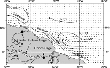
The northwestern tropical Atlantic is also an area where another major river in the world, the Orinoco, enters the ocean. The Orinoco River originates in the southern part of Venezuela and discharges waters from about 31 major and 2000 minor tributaries into the western tropical Atlantic. These waters are most of the time transported into the southeastern Caribbean sea, and during the rainy season, a larger but unquantified fraction of the plume also flows east around Trinidad and Tobago into the Caribbean. The Orinoco is considered to be the third largest river in the world in terms of volumetric discharge (after the Amazon and the Congo), discharging an average of *3.6 9 104 m3 s-1 (Meade et al. 1983; Muller-Karger et al. 1989; Vörösmarty et al. 1998). Low discharge occurs during the dry season (January–May) and high discharge during the rainy season (July–October) as a result of the meridional migration of the ITCZ.
The freshwater discharges from the Amazon and Orinoco Rivers spread outward into the western equatorial Atlantic Ocean while continually mixing with surrounding salty ocean surface water. The averaged geographical distribution of the low-salinity signatures of the Amazon and Orinoco River plumes can be revealed with historical in situ surface salinity data. However, only satellite remote sensing data are known to provide means to monitor the wide surface dispersal of these two fresh pools, with ocean color data being the first to illustrate Amazon plume reach to well beyond 1,000 km (Muller-Karger et al. 1988). Since these first observations, the application of ocean color, altimetry, and SST satellite mapping in this region has increased in its sophistication, showing the ability to track surface plume area (e.g., Hu et al. 2004; Molleri et al. 2010), fronts along the shelf to the northwest (Baklouti et al. 2007), and northward propagating eddies or waves shed near the North Brazil Current (NBC) retro reflection region, the so-called NBC rings (Ffield 2005; Goni and Johns 2001; Garzoli et al. 2004). In each case, the satellite data are able to provide time-resolved information on advective processes up to certain limits that include cloud cover, minor SST and ocean color gradients, non-conservative dilution processes for the ocean color to salinity conversions (Salisbury et al. 2011), and baroclinicity and subgrid variability of the altimetry sea surface height anomaly tracking of the NBC rings.
The advent of satellite measurements of sea surface salinity (SSS) provides a unique opportunity to study the spatio-temporal behavior of SSS in association with large river plumes from synoptic to interannual time scales. A brief summary of the major published science involving satellite SSS and the monitoring of the Amazon and Orinoco river plumes are given in the sections here below.
First demonstrations of the use of passive Microwave data for Amazon Plume monitoring
As first evidenced by Reul et al. 2009 using the Advanced Microwave Scanning Radiometer–Earth Observing System, passive remote sensing data at low microwave frequencies can be successively used to complement these more "classical" satellite observations to better follow the temporal evolution and spatial distribution of surface salinity within and adjacent to the Amazon River plume. Time series (2003–2007) of surface salinity estimated using this method and corresponding satellite cdm absorption (acdm) data were further analyzed in Salisbury et al. 2011 and documented a plume of freshened, colored water emanating from the Amazon. Salinity and acdm were generally coherent, but there were regions in which spatial patterns of salinity and acdm did not coincide. Salinity was oppositely phased with discharge, whereas acdm was in phase but lagged discharge and typically remained high after maximum discharge. Along the river plume trajectory, acdm was inversely correlated with salinity, yet there was considerable deviation from conservative mixing behavior during all seasons. Positive anomalies in a linear relationship between salinity and acdm corresponded to areas of enhanced satellite‐retrieved net primary productivity, suggesting the importance of phytoplankton biomass or its subsequent remineralization as a source of cdm. Negative anomalies tended to predominate at the distal sections of the plume trajectories, an observation consistent with the process of photo‐oxidation of cdm over observed time scales of days to weeks.
Satellite SSS to better study Amazon/Orinoco river Plume interactions with Hurricanes
At its seasonal peak the Amazon/Orinoco plume covers a region of 106 km2 in the western tropical Atlantic with more than 1 m of extra freshwater, creating a near‐surface barrier layer (BL) that inhibits mixing and warms the sea surface temperature (SST) to >29°C. Grodsky et al., 2012 first shown that SSS observations from the Aquarius/SACD and SMOS satellites help elucidate the ocean response to hurricane Katia, which crossed the plume in early fall, 2011. Its passage left a 1.5 psu high haline wake covering >105 km2 (in its impact on density, the equivalent of a 3.5°C cooling) due to mixing of the shallow BL. Destruction of this BL apparently decreased SST cooling in the plume, and thus preserved higher SST and evaporation than outside. Combined with SST, the new satellite SSS data was shown to provide a new and better tool to monitor the plume extent and quantify tropical cyclone upper ocean responses with important implications for forecasting.
An analysis was later presented in Reul et al., 2014 for the spatial and intensity distributions of North Atlantic extreme atmospheric events crossing the buoyant Amazon‐Orinoco freshwater plume. The sea surface cooling amplitude in the wake of an ensemble of storm tracks traveling in that region was estimated from satellite products for the period 1998–2012. For the most intense storms, cooling is systematically reduced by ∼50% over the plume area compared to surroundings open‐ocean waters. Historical salinity and temperature observations from in situ profiles indicate that salt‐driven vertical stratification, enhanced oceanic heat content, and barrier‐layer presence within the plume waters are likely key oceanic factors to explain these results. Satellite SMOS surface salinity data combined with in situ observations were further used to detail the oceanic response to category 4 hurricane Igor in 2010. Argo and satellite measurements confirm the haline stratification impact on the cooling inhibition as the hurricane crossed the river plume. Over this region, the SSS mapping capability was further tested and demonstrated to monitor the horizontal distribution of the vertical stratification parameter. SMOS, Aquarius and SMAP SSS data can thus be used to consistently anticipate the cooling inhibition in the wake of TCs traveling over the Amazon‐Orinoco plume region.
Using a regional ocean model, Newinger and Toumi (2015) tried to separate the potential impact of river freshwater and light absorption on ocean temperatures, stability, and TC intensity. While the freshwater plume stabilizes the water column, there is no significant change in sea surface temperatures. However, increased stability and temperature inversions may reduce surface cooling feedbacks. The cooling inhibition index (CI) is +2.2 (J/m2) larger when the river freshwater plume is present. Ocean color in the river plume on the other hand, blocks the deeper ocean from sunlight, leading to moderate surface warming (+0.1°C) and substantial subsurface cooling (−0.3°C 100 m mean temperature). As a consequence cold water is more readily available to passing storms and the CI decreases by −2.1 (J/m2) . Using simple, idealized relationships between expected surface cooling and TC intensity, we find that river‐induced stability enhances strong TCs by up to −5 to −12 hPa, while ocean color may reduce intensity by +8 hPa to +16 hPa. The net impact of the colored plume is negligible for weak storms and a slight intensity reduction for stronger cyclones. Within the Amazon and Orinoco plume, the river freshwater effect may thus be substantially reduced or even offset by light absorbing particles.
The evolution of three successive hurricanes (Katia, Maria, and Ophelia) was investigated by Androulidakis et al., (2016) over the river plume area formed by the Amazon and Orinoco river outflows during September of 2011. The study focused on hurricane impacts on the ocean structure and the ocean feedback influencing hurricane intensification. High-resolution (1/25° × 1/25° horizontal grid) numerical simulations of the circulation in the extended Atlantic Hurricane Region (Caribbean Sea, Gulf of Mexico, and Northwest Atlantic Ocean) were used to investigate the upper ocean response during the three hurricane-plume interaction cases. The three hurricanes revealed different evolution and intensification characteristics over an area covered by brackish surface waters. The upper ocean response to the hurricane passages over the plume affected region showed high variability due to the interaction of oceanic and atmospheric processes. The existence of a barrier layer (BL), formed by the offshore spreading of brackish waters, probably facilitated intensification of the first storm (Hurricane Katia) because the river-induced BL enhanced the resistance of the upper ocean to cooling. This effect was missing in the subsequent two hurricanes (Maria and Ophelia) as the eroded BL (due to Katia passage) allowed the upper ocean cooling to be increased. As a consequence, the amount of ocean thermal energy provided to these storms was greatly reduced, which acted to limit intensification. Numerical experiments and analyses, in tandem with observational support from Aquarius, lead to the conclusion that the presence of a river plume-induced BL is a strong factor in the ocean conditions influencing hurricane intensification.
The main objective of a study conducted in Hernandez et al., 2016 was to quantify the effects of the Amazon‐Orinoco river discharges in modulating the amplitude of TC‐induced cooling in the western Tropical Atlantic. Their approach is based on the analysis of TC cool wake statistics obtained from an ocean regional numerical simulation with ¼º horizontal resolution over the 1998–2012 period, forced with realistic TC winds. In both model and observations, the amplitude of TC‐induced cooling in plume waters (0.3–0.4ºC) is reduced significantly by around 50–60% compared to the cooling in open ocean waters out of the plume (0.6–0.7ºC). A twin simulation without river runoff shows that TC‐induced cooling over the plume region (defined from the reference experiment) is almost unchanged (∼0.03ºC) despite strong differences in salinity stratification and the absence of barrier layers. This argues for a weaker than thought cooling inhibition effect of salinity stratification and barrier layers in this region. Indeed, results suggest that haline stratification and barrier layers caused by the river runoff may explain only ∼10% of the cooling difference between plume waters and open ocean waters. Instead, the analysis of the background oceanic conditions suggests that the regional distribution of the thermal stratification is the main factor controlling the amplitude of cooling in the plume region.
Interannual SSS variability in the Amazon/Orinoco river plume region
The fresh Amazon/Orinoco plume covers in excess of 106 km2 in late summer–early fall forming a near-surface barrier layer that reduces exchange with the cooler, saltier water below. Barrier layers and higher water turbidity keep SST in the region high and thus are factors in the development of fall season hurricanes. Year to year changes in key properties of salinity and areal coverage may depend on a number of factors including river discharge, ocean rainfall, vertical entrainment rate, and horizontal advection. Grodsky et al., 2014a, used SSS observations from the Aquarius/SACD and SMOS satellites to show that the plume was 1 psu saltier in early fall 2012 than in the previous fall (despite a stronger Amazon discharge in 2012) and explores the possible causes. The study concluded that the most likely causes of the 2012 salinification are a relative deficit of rainfall over the inflow to the plume region well southeast of the plume in spring and a weaker North Brazil current in spring–summer. The results suggest that tracking spring rainfall can potentially contribute to forecasting the Amazon plume stratification during the fall hurricane season.
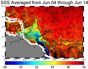
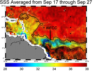
Sea surface salinity (SSS) measurements from the Aquarius/SAC‐D satellite analyzed in Grodsky et al. 2014b reveal the seasonal development of a local salinity maximum in the northwestern tropical Atlantic in boreal winter to early spring. This seasonal tropical SSS maximum, which is confirmed by comparison to in situ observations, is centered at 8°N, and is up to 0.5 psu saltier than the surrounding water despite its location in the latitude band of the highly precipitating Intertropical Convergence Zone. Its existence seems to be the result of the differing phases in the seasonal variations of Amazon discharge and ocean currents. In late boreal fall/winter, when the discharge is at its minimum, but the North Brazil Current (NBC) and its retroflection are still present, a mixture of high‐salinity water of equatorial and South Atlantic origin is transported along the shelf break by the NBC retroflecting into the western part of the North Equatorial Countercurrent (NECC). This salt transport produces the salty signature of the western part of the NECC, which is seen as a localized salinity maximum on satellite imagery, in contrast to the fresh signature present in summer‐early fall. The seasonal slowing/reversal of the NECC in boreal spring stops this eastward salt transport, thus leading to the disappearance of this northwestern tropical SSS maximum.
The transport of low-salinity water northward in the tropical and subtropical North Atlantic Ocean influences upper-ocean stratification, vertical mixing, and sea surface temperature (SST). In Foltz et al. (2015), satellite and in situ observations were used to trace low-salinity water northward from its source in the equatorial Atlantic and to examine its modification through air–sea fluxes and vertical mixing. In contrast to gridded climatologies, which depict a gradual northward dispersal of surface freshwater from the equatorial Atlantic, satellite observations and direct measurements from four moorings in the central tropical North Atlantic show a distinct band of surface freshwater moving northward from the equatorial Atlantic during boreal fall through spring, with drops in sea surface salinity (SSS) of 0.5–2.5 psu in the span of one to two weeks as the low SSS front passes. The ultimate low-latitude source of the low SSS water is found to be primarily Amazon River discharge west of 40°W and rainfall to the east. As the low-salinity water moves northward between 8° and 20°N during October–April, 70% of its freshwater in the upper 20 m is lost to the combination of evaporation, horizontal eddy diffusion, and vertical turbulent mixing, with an implied rate of SSS damping that is half of that for SST. During 1998–2012, interannual variations in SSS along 38°W are found to be negatively correlated with the strength of northward surface currents. The importance of ocean circulation for interannual variations of SSS and the small damping time scale for SSS emphasize the need to consider meridional freshwater advection when interpreting SSS variability in the tropical–subtropical North Atlantic.
As shown in Grodsky et al. (2015) , Aquarius SSS reveals the presence of interannual variations in the Caribbean with about 0.5 psu change between salty and fresh events, which propagate westward across that basin at an average speed of 11 cm/s and are preceded by corresponding SSS anomalies east of the Lesser Antilles. These upstream SSS anomalies are produced by interannual changes in the Amazon plume. Their presence is verified using in situ measurements from the northwest tropical Atlantic station. In contrast to SSS, which displays westward propagation, SST changes almost immediately across the Caribbean, suggesting large‐scale atmospheric processes have a primary role in regulating interannual SST in contrast to SSS. A global 1/10° mesoscale ocean model is used to quantify possible origination mechanisms of the Caribbean salinity anomalies and their fate. Simulations confirm that they are produced by anomalous horizontal salt advection, which conveys these salinity anomalies from an area east of the Lesser Antilles across the Caribbean. Anomalous horizontal advection is dominated by mean currents acting on anomalous salinity. The model suggests that interannual Caribbean salinity anomalies eventually enter the Florida Current and reach the Gulf Stream 6–12 months after crossing the central Caribbean. Previous studies link the origin of salinity anomalies in the Amazon plume to variations in the annual freshwater discharge from the continent. In this model interannual discharge variations are absent while simulated SSS variability is in line with observations. This suggests that interannually forced ocean dynamics plays a key role in river plume variability and its spatial dispersion.
Space‐time variability of SSS in the Atlantic Ocean (33°S–80°N) was analyzed in Martins et al. (2015) using near‐surface salinity observations from the period 1980–2013 jointly with the output from an eddy‐resolving numerical ocean simulation. Results show a good agreement between in situ and model results in terms of spatial and temporal mean SSS patterns, geographically varying SSS variability, and spatial and temporal scales of SSS variability. A good agreement exists also for estimates of the amplitude and phase of the annual cycle of SSS with the model providing more spatial details of SSS variability, which cannot be resolved by observations, especially near ocean margins and in shelf areas. Dominant spatial and temporal scales of SSS variability are, respectively, between 100 and 250 km and between 30 and 70 days in most of the Atlantic when the annual cycle of the SSS is included. However, smaller‐scale salinity features are also present, which show temporal decorrelation scales of only 3–5 days throughout the Atlantic. This fast variability must be considered when producing weekly averaged salinity products from satellite.
Taking advantage of the spatially dense, multi-year time series of global Sea Surface Salinity (SSS) from SMOS and Aquarius concurrent satellite missions, the spatial and temporal decorrelation scales of SSS in the Tropical Atlantic 30°N–30°S were quantified in Tzortzi et al. (2016) for the first time from Space observations. Given the dominance of the seasonal cycle in SSS variability in the region, the length scales are calculated both for the mean and anomaly (i.e. seasonal cycle removed) SSS fields. Different 7–10 days composite SSS products from the two missions are examined to explore the possible effects of varying resolution, bias corrections and averaging characteristics. With the seasonal cycle retained, the SSS field is characterized by strongly anisotropic spatial variability. Homogeneous SSS variations in the Tropics have the longest zonal scales of over ~ 2000 km and long temporal scales of up to ~ 70–80 days, as shown by both SMOS and Aquarius. The longest meridional scales, reaching over ~ 1000 km, are seen in the South Atlantic between ~ 10°–25°S, most discernible in Aquarius data. The longest temporal scales of SSS variability are reported by both satellites to occur in the North-West Atlantic region 15°–30°N, at the Southern end of the Sargasso Sea, with SSS persisting for up to 150–200 days. The removal of the seasonal cycle results in a noticeable decrease in the spatio-temporal decorrelation scales over most of the basin. Overall, with the exception of the differences in the South Atlantic, there is general agreement between the spatial and temporal scales of SSS from the two satellites and different products, despite differences in individual product calibration and resolution characteristics. These new estimates of spatio-temporal decorrelation scales of SSS improve our knowledge of the processes and mechanisms controlling the Tropical Atlantic SSS variability, and provide valuable information for a wide range of oceanographic and modelling applications.
Fournier et al. (2017) conducted a study that investigates SSS and sea surface temperature (SST) variations in the tropical Atlantic east of the Lesser Antilles, a region where freshwater advection from the Amazon and Orinoco Rivers, may potentially impact air‐sea interaction. Observations are used to document later‐summer variability and evaluate offshore riverine transport from 2010 to 2014. During this period, the largest difference in plume‐affected areas, defined as the extent covered by SSS lower than 35.5 pss, is found between 2011 and 2014. Plume waters covered 92% of the study region in 2011 and 60% in 2014, with the average SSS in the study region being 2 pss lower in 2011. Lagrangian particle tracking based on satellite‐derived ocean currents is used to diagnose the impact of the river plumes on SSS and SST from 2010 to 2014. Northward freshwater flux in summer 2014 was significantly weaker than fluxes in 2010–2013. This difference is not due to interannual discharge variability, but to significant changes in eddy‐driven transport and cross‐shore winds. In particular, the stronger cross‐shore wind in May 2014 restricted offshore freshwater flow and lead to a smaller plume‐affected area. Persistent SST gradients are often found near the plume edge, which may have implications for ocean‐atmosphere coupling associated with atmospheric convection. SST in the study region was 1°C higher in 2010 compared to other years, and is related to basin‐scale ocean‐atmosphere processes. Interannual variation in Amazon advective pathways and the associated SSS changes are also influenced by changes in the ITCZ position between 2011 and 2014.
SSS, Ocean Color and bio-geochemistry in the Plumes
Fournier et al. (2015) found that in the Amazon river plume, SSS and upper water column optical properties such as the absorption coefficient of colored detrital matter (acdm) are strongly negatively correlated (<−0.7). Local quasi‐linear relationships between satellite SSS and acdm were derived for these plume waters over the period of 2010–2013 using spaceborne SSS and ocean color measurements. Results allow unprecedented spatial and temporal resolution of this coupling. These relationships are then used to estimate SSS in the Amazon plume based on ocean color satellite data. This new product is validated against SMOS and in situ data and compared with previously developed SSS retrieval models. We demonstrate the potential to estimate tropical Atlantic SSS for the extended period from 1998 to 2010, prior to spaceborne SSS data collection.
A synergistic tool for studying the Amazon River plume dynamics based on a novel algorithm for deriving sea surface salinity (SSS) from MODIS reflectance data together with SSS data from the SMOS and Aquarius satellites and the TOPAZ data assimilation system was proposed in Korosov et al. (2015). The new algorithm is based on a neural network to relate spectral remote sensing reflectance measured by MODIS with SSS measured by SMOS in the Amazon River plume. The algorithm is validated against independent in situ data and is found to be valid in the range of SSS from 29 to 35 psu, for the period of highest rates of Amazon River discharge with RMSE = 0.79 psu and r2 = 0.84. Monthly SSS fields were reconstructed from the MODIS data for late summers from 2002 to 2012 at a 10 km resolution and compared to surface currents and SSS derived from the TOPAZ reanalysis system. The two data sets reveal striking agreement, suggesting that the TOPAZ system could be used for a detailed study of the Amazon River plume dynamics. Both the position and speed of the North Brazilian Current as well as the spreading of the Amazon River plume are monitored. In particular, a recurrent mechanism was observed for the spreading of the rivers plumes, notably that the fresh water is usually advected toward the Caribbean Sea by the North Brazilian Current but get diverted into the tropical Atlantic when North Brazil Current Rings are shed.
Approximately a quarter of the carbon dioxide (CO2) that we emit into the atmosphere is absorbed by the ocean. This oceanic uptake of CO2 leads to a change in marine carbonate chemistry resulting in a decrease of seawater pH and carbonate ion concentration, a process commonly called “Ocean Acidification”. As discussed in Land et al. (2015) and Salisbury et al. (2015), Salinity data are key for assessing the marine carbonate system, and new space-based salinity measurements enable the development of novel space-based ocean acidification assessment. Recent studies have highlighted the need to develop new in situ technology for monitoring Ocean Acidification (OA), but the potential capabilities of space-based measurements remain largely untapped. Routine measurements from space can provide quasi-synoptic, reproducible data for investigating processes on global scales; they may also be the most efficient way to monitor the ocean surface. As the carbon cycle is dominantly controlled by the balance between the biological and solubility carbon pumps, innovative methods to exploit existing satellite sea surface temperature and ocean color, and new satellite sea surface salinity measurements, are needed and will enable frequent assessment of ocean acidification parameters over large spatial scales. Space-based observations offer unique capabilities for studying spatial and temporal dynamics of the upper ocean inorganic carbon cycle and, in turn, supporting research tied to OA. Satellite sensors measuring sea surface temperature, color, salinity, wind, waves, currents, and sea level enable a fuller understanding of a range of physical, chemical, and biological phenomena that drive regional OA dynamics, such as in the Amazon plume region, as well as the potentially varied impacts of carbon cycle change on a broad range of ecosystems. In these 2 papers, the authors updated and expanded on previous work that addresses the benefits of space-based assets for OA and carbonate system studies. Carbonate chemistry and the key processes controlling surface ocean OA variability were reviewed. Synthesis of present satellite data streams and their utility in this arena were discussed, as were opportunities on the horizon for using new satellite sensors with increased spectral, temporal, and/or spatial resolution. Applications that include the ability to track the biochemically dynamic nature of water masses, to map coral reefs at higher resolution, to discern functional phytoplankton groups and their relationships to acid perturbations, and to track processes that contribute to acid variation near the land-ocean interface were outlined.
The influence of salinity on tropical Atlantic instability waves
SSS data derived from the Aquarius/SAC‐D satellite mission were analyzed by Lee et al. (2014) along with other satellite and in situ data to assess Aquarius' capability to detect tropical instability waves (TIWs) and eddies in the tropical Atlantic Ocean and to investigate the influence that SSS has on the variability. Aquarius data show that the magnitude of SSS anomalies associated with the Atlantic TIWs is ±0.25 practical salinity unit, which is weaker than those in the Pacific by 50%. In the central equatorial Atlantic, SSS contribution to the mean meridional density gradient is similar to sea surface temperature (SST) contribution. Consequently, SSS is important to TIW‐related surface density anomalies and perturbation potential energy (PPE). In this region, SSS influences surface PPE significantly through the direct effect and the indirect effect associated with SSS‐SST covariability. Ignoring SSS effects would underestimate TIW‐related PPE by approximately three times in the surface layer. SSS also regulates the seasonality of the TIWs. The boreal‐spring peak of the PPE due to SSS leads that due to SST by about one month. Therefore, SSS not only affects the spatial structure, but the seasonal variability of the TIWs in the equatorial Atlantic. In the northeast Atlantic near the Amazon outflow and the North Brazil Current retroflection region and in the southeast Atlantic near the Congo River outflow, SSS accounts for 80–90% of the contribution to mean meridional density gradient. Not accounting for SSS effect would underestimate surface PPE in these regions by a factor of 10 and 4, respectively