Mississippi river plume
Literature Review
Overview
The Mississippi River is the largest river in North America and the sixth largest in the world in terms of runoff (Dai & Trenberth, 2002). It discharges over 13 000 m3/s of freshwater each year into the Gulf of Mexico (GoM) with a strong seasonal cycle reaching a maximum in spring (March–June) and a minimum in fall (September–November) (Gierach, Vazquez-Cuervo, Lee, & Tsontos, 2013). Local wind stress plays an important role in the spreading of freshwater from the Mississippi River in the GoM. The presence of southerly/southeasterly winds in spring/summer (i.e., period of high discharge) promotes eastward transport of the freshwater associated with the Mississippi River plume, whereas northeasterly/northerly winds in fall/winter (i.e., period of lowdischarge) shift the transport of freshwater westward (Morey, Martin, O'Brien, Wallcraft, & Zavala-Hidalgo, 2003; Morey, Schroeder, O'Brien, & Zavala-Hidalgo, 2003). The freshwater plume not only affects local stratification and circulation within the GoM, but can also potentially impact the North Atlantic circulation on longer time scales. In addition to freshwater, the Mississippi River discharges a large amount of dissolved matter into the GoM, including Colored Dissolved Organic Matter (CDOM). The major source of CDOM in the GoM coastal waters is river runoff of terrigenous organic matter (DelCastillo et al., 2000). This exerts a strong influence on the biological, chemical, and physical properties of the northern Gulf of Mexico (D'Sa & Miller, 2003; DelCastillo et al., 2000; Müller-Karger, Walsh, Evans, & Meyers, 1991), wherein a strong negative correlation exists between CDOM and SSS in the GoM (Hu et al., 2003). A negative correlation between the two parameters indicates that both parameters serve as passive tracers of river plume waters. Enhanced sediment and nutrient loading by the Mississippi River plume impacts the salinity balance and alters the marine ecosystem in the GoM (Dietrich, Bowman, Korotenko, & Bowman, 2014). Therefore monitoring the spatial and temporal variability of the Mississippi River plume is important to biophysical interactions at local and regional scales.
The advent of satellite measurements of sea surface salinity (SSS) provides a unique opportunity to study the spatio-temporal behavior of SSS in association with large river plumes from synoptic to interannual time scales. A brief summary of the major published science involving satellite SSS and the monitoring of the Mississippi river plume in the sections here below.
Validation of Satellite SSS in the Mississippi river plume
In Ghani et al., 2014, near-surface properties (sea surface temperature, conductivity, and dissolved oxygen) were measured by a new type of unmanned vessel named the ‘SailBuoy’ during a two-month mission in the northern Gulf of Mexico in March–May, 2013, and covering a cumulative total distance of approximately 2400 km. Observed surface temperature and salinity records were compared with Aquarius Level 2 (along-track) and Level 3 (gridded to daily, 1° horizontal resolution) SSS data and the salinity fields from a regional ocean modeling system, respectively. It was found that the Aquarius data are too coarse in space and time to resolve small-scale features observed with the SailBuoy. However, away from the coast, the level 3 Aquarius salinities agree well with the SailBuoy observations, though the Level 2 data have somewhat higher values.
Flood signatures in the SSS of the Mississippi river plume
Gierach et al.,2013 documented the SSS response in the GoM to a large-flooding event of the Mississippi River in 2011 and the associated pathway and residence time of the river plume. Aquarius and SMOS SSS data were used along with satellite-derived chl-a and ocean surface current products to study the salinity freshening associated with the record 2011 Mississippi River flooding event in the GoM. series of USGS daily mean discharge revealed maximum flooding of the Mississippi River in May 2011. In association with this discharge event, SSS freshening was observed from June to August 2011 (1–3 months after peak discharge) in the GoM that then receded and became unidentifiable from satellite observations by October 2011 (5 months after peak discharge). Seasonal wind patterns and the general circulation of the GoM dramatically impacted the observed salinity response. The observed salinity response from Aquarius was consistent with SMOS SSS observations and MODIS chl-a concentrations in terms of the pathway and transit time of the river plume spreading. A passive tracer simulation confirmed the pathway and transit time of freshwater spreading observed by Aquarius and SMOS in the GoM.
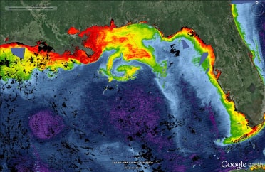
Later, during the May 2015 Texas flood, high precipitation and saturated surface soils contributed to a record river discharge event that impacted both land and ocean. As shown in Fournier et al., 2016b, the large precipitation anomaly during that month over the region caused surface soil moisture to rise to the most saturated levels since the beginning of the SMOS observation period. SMAP soil moisture maps also show a saturated land surface over the months of May and June. The intense rainfall and limited infiltration produced record runoff for the major hydrologic basins into the GoM coastal region. SMAP and SMOS SSS measurements show the unusual presence of freshwater offshore in the north central GoM in addition to the commonly observed Mississippi River plume in the east. Analysis of SSS observations in conjunction with ocean surface current estimates indicates that the freshwater plume in north central GoM originated from the Texas shelf right after the flooding event and was subsequently carried northwestward along the Texas coast by coastal currents during June–July then southward away from shore in August by the currents in the eastern flank of an anticyclonic eddy shed off from a particularly strong Loop Current earlier in the year. This unusual freshwater plume, together with the typical Mississippi River plume in the east, formed a rare horseshoe pattern in the Gulf.
Seasonal and interannual variations of SSS near the mouth of the Mississippi River
Seasonal and interannual variations of SSS in the GoM near the mouth of the Mississippi River were studied by Fournier et al., 2016 using SSS measurements derived from SMOS and Aquarius during 2010–2014. A seasonal cycle is clearly observed in SSS, with an SSS maximum during December–April and an SSS minimum in July–August. The averaged magnitude of the seasonal variation is about 4 pss. Interannual changes are also observed, with the lowest SSS in summer 2011 and the highest SSS in summer 2012 and a difference of 4.2 pss. Therefore, the magnitude of interannual changes can be comparable to that of the seasonal cycle. Their analysis suggests that the seasonal variations of SSS near the Mississippi River mouth are consistent with variations in Mississippi River discharge. Evaporation minus precipitation and ocean dynamics play a minor role. River discharge also contributes to the interannual variation of SSS, especially during summer 2011 and to some extent the highest summer minimum in 2012 in terms of timing, but not magnitude. For the latter, ocean dynamics and E–P also contribute. The implications of the findings to ocean modeling and hypoxic zone monitoring were also discussed.
Correlation SSS/SST/CHLa in the Mississippi River Plume
The Level 3-version 4 SSS data observed by Aquarius were used in Rajabi et al., 2017 to examine the variability of SSS in Gulf of Mexico for the 2012-2014 time periods. The highest SSS value occurred in April 2013 with the value of 36.72 psu while the lowest value (35.91 psu) was observed in July 2014. Based on the monthly distribution maps, it was observed that east part of the region has lower salinity values than the west part for all months mainly because of the currents which originate from low saline waters of the Caribbean Sea and furthermore the eastward currents like loop current. Also the minimum amounts of salinity occur in coastal waters where the river runoffs make fresh the high saline waters. High correlation of SST on SSS variations was found and a relationship between the SSS, SST, CHLa and the latitude was derived.
Estimating SSS from Ocean Color in coastal water and comparison with Satellite SSS
Using a neural network technique trained on in situ SSS, SST and optical reflectances data, Chen and Hu (2017) derived an empirical model to retrieve SSS from MODIS (Moderate Resolution Imaging Spectroradiometer) and SeaWiFS (Sea-Viewing Wide Field-of-View Sensor) estimated remote sensing reflectance. The model was tested in the Mississippi-Atchafalaya coastal region and showed an overall performance of root mean square error (RMSE) =1.2. Comparison with concurrent Aquarius-derived SSS maps (110-km resolution) showed similar agreement in offshore waters as indicated above, but the new 1-km resolution SSS maps revealed more finer-scale features as well as salinity gradients in coastal waters.